


Advanced GIS Applications
An advanced professional training program aimed at developing participants' skills in using Geographic Information Systems (GIS) to analyze and manage spatial data proficiently. The course covers GIS applications across a wide range of engineering and surveying fields, enabling participants to create advanced digital maps, build complex geographic databases, and perform in-depth spatial analyses to support engineering, surveying, and urban and environmental planning projects. The course relies on the latest globally recognized GIS technologies and tools, providing participants with an in-depth understanding of how to integrate and analyze spatial data efficiently to support accurate strategic decision-making. This training is designed for professionals seeking to enhance their capabilities in using GIS in advanced work environments, focusing on providing innovative solutions to complex surveying and engineering challenges.
Types of Geographic Data and How to Collect It
This section covers the types of data used in GIS, such as raster and vector data. Participants will learn the methods for collecting these data using various surveying techniques like GNSS and satellite imagery. Additionally, they will understand how to utilize this data to develop infrastructure projects with high precision.
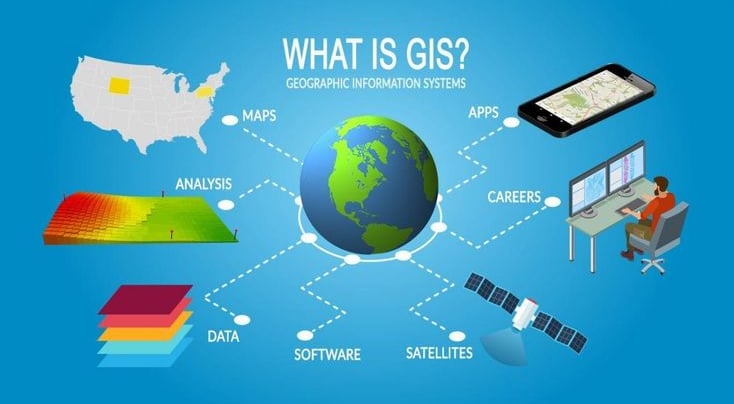
Introduction to Geographic Information Systems (GIS)
In this section, participants will be introduced to the concept of Geographic Information Systems (GIS) and their essential role in engineering projects, enabling the management and analysis of spatial data with precision. The basic components of GIS will be explored, highlighting the significance of these systems in collecting and analyzing spatial data to support decision-making across various engineering and urban planning fields.


Core Training Modules
A comprehensive journey that starts from the basics and progresses to mastery in all surveying specialties.
Spatial Analysis and Practical Applications
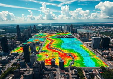
This section focuses on using spatial analysis tools to extract valuable geographic information. Participants will learn techniques such as Overlay and Buffer to analyze terrain and infrastructure. They will also learn how to use these tools to analyze areas, calculate distances, and predict the environmental and community impacts of engineering projects.
Designing and Building Geodatabase
In this section, participants will be trained on how to create integrated geodatabases tailored to the needs of engineering projects. The focus will be on strategies for managing and organizing geographic data within GIS software, as well as learning how to link geodatabases with other engineering programs such as AutoCAD and Civil 3D to exchange data and ensure accuracy in engineering designs.


GIS Applications in Engineering Surveying
This section focuses on how to use GIS systems in engineering surveying to enhance the accuracy of geographic analysis. Participants will be trained to apply GIS tools in topographic surveying, infrastructure analysis, and urban planning. Emphasis will be placed on how to link survey results using various surveying devices such as Total Station and GNSS, ensuring the creation of accurate and executable designs.
Creating Digital Maps Using GIS
Participants will learn how to design digital maps using GIS systems and how to customize these maps to meet the needs of various projects. The focus will be on adding geographic and graphic details, as well as integrating these maps with other programs such as AutoCAD and Civil 3D to ensure seamless data and result integration.


Our Services
Contact
Sales
© 2025. All rights reserved.
We provide surveying solutions
MSI Training Academy
World-class engineering training