


Comprehensive Free Workshop on Digital Surveying and LiDAR Scanning Technology
How to Transition from Traditional Surveying to the World of BIM and Digital Twins

Integrated Surveying Diploma
The most important and comprehensive program in the Middle East for qualifying the engineers and surveyors of the future with a complete professional level.
The Integrated Surveying Diploma offered by MSI Academy is not just a traditional training course; it represents a comprehensive qualification path, designed to build a new generation of experts capable of executing and leading large-scale surveying and engineering projects with efficiency and professionalism, adhering to the highest internationally recognized standards.
The content of the diploma has been developed to provide a comprehensive coverage of all theoretical and practical aspects of surveying work, from surveying, marking, and design, to analysis, processing, and the preparation of accurate technical reports, all using the latest devices and engineering software.
The diploma covers the following aspects:
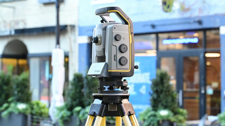
Two and Three-Dimensional Ground Surveying Technologies and Equipment
Total Station - GNSS & GPS
Digital & Auto Levels - Laser Levels
3D Laser Scanners - Mobile Mapping Systems
Advanced Specialized Surveying
Construction Surveying
Road and Bridge Surveying
Infrastructure and Utility Networks Surveying
Longitudinal and Transverse Profiles
Longitudinal Sections and Engineering Design
Surveying and Marking on-site
Engineering Software and Processing
AutoCAD - Civil 3D
Revit - 3ds Max
Google Earth Pro - Excel
Device Integration Programs and Data Analysis
Training Benefits
Hands-on practical training on all original and certified surveying equipment.
Real-world field applications on actual projects under the supervision of a team of engineers and consultants.
Use of original versions of all engineering software with practical explanations of how to link them to devices.
Full coverage of all surveying work stages from office to site.
Transforming the trainee from a mere user of technologies into a specialist who can understand and utilize them to lead both field and office work.
Accredited Certificates
A certified and accredited certificate from MSI Academy for Training.
The option to authenticate certificates with the Egyptian Engineers Syndicate and the Egyptian Ministry of Foreign Affairs.
Certificates valid for accreditation inside and outside Egypt, supported by official stamps and documentation.
Advanced Engineering Surveying Diploma
The Advanced Engineering Surveying Diploma aims to provide participants with in-depth knowledge and specialized skills in three main areas: construction engineering surveying, road and utilities engineering surveying, and infrastructure engineering surveying. This diploma is designed to enhance professionals' capabilities in handling advanced engineering projects and provides training on the latest technologies and equipment in this field.
Advanced Engineering Software Course
This course is designed to prepare participants to use the latest specialized engineering software in the field of surveying and civil engineering. The course covers a range of advanced software such as AutoCAD, Civil 3D, Revit, 3ds Max, and Google Earth, in addition to programs that link equipment with software. Trainees are trained on the latest original versions of these programs, enabling them to complete their projects with high efficiency and precision, and qualifying them to work in advanced work environments.


Integrated Surveying Equipment Course
A specialized training course designed to teach trainees how to use the latest surveying equipment in the market. The course includes learning how to handle Total Stations, GPS, 3D Laser Scanners, Levels, and Laser Levels, in addition to training on the software that links the equipment with engineering programs such as AutoCAD and Civil 3D. The course focuses on practical applications of the equipment in various engineering projects and equips trainees with the necessary skills to ensure accuracy and efficient execution of surveying tasks in the field.
Core Training Modules
A comprehensive journey that starts from the basics and progresses to mastery in all surveying specialties.
Geodetic Coordinate Systems and Transformations Course
A core module for understanding the reference framework for all surveying and mapping work, this course covers global coordinate systems like WGS84, as well as local Egyptian systems like ETM, alongside geodetic models such as GRS80. The module also addresses geographic projection systems like UTM, with practical training on how to accurately transform between all these systems to ensure seamless integration between field data and execution maps, ensuring the highest levels of precision in surveying and engineering projects.
Professional GNSS Surveying
This advanced course focuses on training participants in the techniques of surveying using modern GNSS (Global Navigation Satellite Systems) technologies, including GPS. The course covers fieldwork methods with dual-frequency GNSS devices, using them for high-precision surveying and staking operations. It also includes training on project setup, device configuration, data collection, and analysis using specialized software to produce accurate maps and reliable engineering reports.


Advanced 3D LiDAR Scanning
This course is specialized in training participants on the techniques of surveying using 3D laser scanning devices, which are among the latest geographic surveying technologies. The course covers how to use these devices to produce accurate 3D models of infrastructure, terrain, and complex areas, along with learning how to process the data using specialized software to transform field surveys into precise maps and detailed analyses.
Our Services
Contact
Sales
© 2025. All rights reserved.
We provide surveying solutions
MSI Training Academy
World-class engineering training